Towards understanding a complex borderscape in northern Sudan: the MUAFS project
The area which is the focus of the archaeological Munich University Attab to Ferka Survey Project (MUAFS) is a stretch along the Nile, including various islands between Attab and Ferka in northern Sudan.
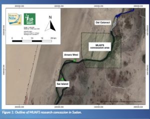
The MUAFS research concession is primarily a geological boundary zone located next to the Dal cataract region and, secondly, a frontier in terms of cultures (Figure 1). During millennia, the region was, on the one hand, the northernmost area of an archaeological culture and, on the other hand, the southernmost area of influence by other cultural groups. The Attab to Ferka region, which also represents the hinterland of the urban sites of Amara West and Sai Island, is, therefore, a perfect case study for a contact space. This contact space in the Middle Nile was shaped by diverse human actors and various interacting communities as a complex social space.
The MUAFS project applies a landscape biography approach, investigating encounters of humans and landscapes in a marginal borderscape with a longue-durée perspective, considering all attested finds from Palaeolithic times until the Islamic age. The major goal is to evaluate the specific living conditions in this contact space with a special focus on humans, human activities, technologies, materiality, and animals.
Rich archaeological remains throughout millennia
The MUAFS concession was previously surveyed in the 1970s by the Sudan Antiquities Service, together with the French Archaeological Research Unit, under the direction of André Vila. Multiple sites, comprising settlement and funerary remains as well as rock art, fortresses and churches, spanning from the Palaeolithic to Post-Medieval periods, were documented.
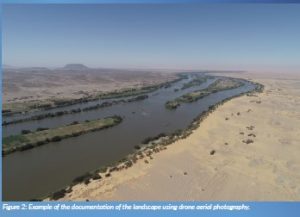
After two years of the COVID-19 pandemic with no fieldwork in Sudan but a focus on remote sensing, we were back in the field in January 2022 and March to April 2022. The MUAFS project conducted a survey as well as aerial photography using a remote-controlled drone DJI Phantom 4 Pro to document both the archaeological sites and the landscape (Figure 2). At present, a total of 266 sites have been documented. This comprises 186 of the 219 sites identified by Vila in the 1970s as well as 80 newly identified sites. This number of sites is still preliminary because parts of Kosha, Mograkka and Ferka on the West bank have not yet been surveyed. This is a task for the approaching fieldwork season in Sudan.
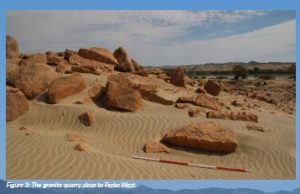
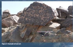
Regarding the types of sites, the most common sites are settlements and burial grounds. However, it is also remarkable that the MUAFS concession includes one granite quarry close to Ferka (Figure 3), at least one gold extraction site and several rock art sites (Figure 4).
As far as the dating of the sites is concerned, the majority belongs to the Medieval time. Bronze Age sites which can be labelled as Kerma and New Kingdom sites and are relevant to the ERC DiverseNile project are also well represented. There are also several multi-period sites, and others were re-used in later periods (e.g. Kerma sites in Medieval times). It needs to be stressed that we could partly correct and specify the dating of some of the sites documented by Vila.
Some general patterns of the distribution of sites throughout the ages are already observable; for example, Medieval sites and Islamic sites are located close to the modern course of the river—an area otherwise void of archaeological sites. This allows the importance of environmental parameters and changing landscapes in the region to be highlighted, in particular, a changed course of the river. One of the highlights of our 2022 MUAFS survey is an exceptionally well-preserved Islamic site located on an island.
Impressive mud brick buildings on the island of Gergetti
Until 2022, our work only focused on the left and right banks of the Nile—but the MUAFS concession also comprises all the islands of the region. While we still did not document the impressive archaeological remains on the island of Firkinarti island close to Ferka, a visit to Gergetti island was undertaken with very remarkable results.
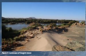
Gergetti (Figure 5) is a beautiful island dominated by sandy dunes, located between Attab East and Attab West with an east-west extension of c. 1.7 km and a north-south extension of c. 250 m. Vila documented two sites on the island—the better preserved one is a fortified village in the southwestern corner of the island (110×70 m) which he associated with the late Medieval period. Vila provided an excellent map of the site, and we could follow in his footsteps and check the present-day preservation.
The enclosure wall of the village has a hexagon shape and is made of mud brick with blocks and pieces of schist stone. In the southern part, the enclosure has already partly collapsed in the times of Vila, but the buildings in the interior are still very well preserved (Figure 6).
A dozen preserved mud brick houses are square or rectangular buildings with one very small room in the back and a larger room in the front. Such a layout and the general appearance of this settlement seem typical of the Funj period. Much progress in research on Funj house architecture has just been made in the last years, most prominently by the UMMA ERC project at Old Dongola. In one of their recent publications, my colleagues Obłuski and Dzierzbicka have pointed out the main characteristics and differences to the Medieval Nubian house types.
Especially since research of Funj period domestic architecture between the Second and Third Cataracts is still limited, our site on Gergetti island has much potential for future exploration. It became obvious that the map of Vila, as useful as it is, needs to be improved in several respects and that some buildings were also omitted on his plan. It is planned to document the site by drone aerial photography and to generate a new georeferenced 3D model as well as detailed plans. Excavations should also be undertaken in selected parts of the town, especially for clarifying building phases. The earliest phase of the settlement would be extremely relevant—not only for further comparisons with Old Dongola and other sites, but also from a historical view of the region of Attab to Ferka. Apart from the architecture, the material culture will give important information on the fine dating (as well as on so many other questions like room function, activities etc.). There is plenty of pottery on the surface, including nice painted wares, and we also found one small piece of glazed ware. Without doubt, undisturbed contexts more useful for dating can be expected below some of the collapsed walls.
For now, Vila’s association of the site with late Medieval times should be modified as most likely Funj period—more on this will be possible when we return to the beautiful island of Gergetti.
Outlook
Important future working steps of the MUAFS project comprise a continuation of the survey, especially in the hinterland and on the islands–Gergetti has illustrated the splendid state of preservation of sites in island locations. Excavations at sites with promising results from the survey will be conducted soon. Finally, there is the urgent necessity for cultural heritage measurements and the protection of sites and monuments in the area between Attab and Ferka, presently endangered by modern construction work, extensions of housing areas, car tracks and modern gold working.
Project name
MUAFS
Project summary
The MUAFS project conducts a regional study of the Middle Nile in Northern Sudan between Attab and Ferka focusing on encounters of humans and landscapes in a marginal borderscape. The archaeological project considers all attested finds from Palaeolithic to Islamic times and compares its results with data from main urban centres of the region.
Project partners
The MUAFS project is based at the Faculty for the Study of Culture at LMU Munich, Germany, taking advantage of the faculty’s strong profile in archaeology around the world. Since 2022, the project is collaborating with the Department of Archaeology of El-Neelain University, Khartoum, Sudan.
Project lead profile
Julia Budka studied Egyptology and Classical Archaeology in Vienna. Professor for Egyptian Archaeology and Art History at LMU Munich since 2015, Budka has been working on international archaeological excavations in Egypt and in Sudan since 1997. Besides the MUAFS project, she directs the ERC DiverseNile project, which conducts archaeological fieldwork in Sudan between Attab and Ferka.
Project contacts
Prof. Dr Julia Budka
Ludwig-Maximilians-Universität München
Institut für Ägyptologie und Koptologie
Katharina-von-Bora-Str. 10
D-80333 München
+49 (0) 89 / 289 27543
www.sudansurvey.gwi.uni-muenchen.de
Funding
The MUAFS project was funded by LMU Munich’s Institutional Strategy LMUexcellent within the framework of the German Excellence Initiative. Its current costs are covered by means of institutional budget.


