Professor Marc Bierkens
The unsustainable depletion of the world’s groundwater severely impacts the environment and is also set to impact the food security of future generations. Despite decades of research on groundwater overuse, we lack knowledge on attainable groundwater reserves and how long they will last before becoming depleted. GEOWAT seeks answers to the all-important questions: how much groundwater is there, and how long will it last?
Rising population numbers and economic development have dramatically increased the demand for food and water (Godfray et al., 2010). Consequently, irrigated agriculture has expanded into dry areas with limited precipitation and surface water (Siebert et al., 2012). This has dramatically intensified the dependence of irrigated crops on groundwater pumping (Wada, van Beek and Bierkins, 2012). Also, the ever-increasing population of megacities without access to clean surface water or piped drinking water (McDonald et al., 2014) has dramatically increased urban groundwater use.
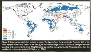
The result of these trends has been the steady increase in the use of non-renewable groundwater resources, i.e. groundwater taken out of storage that will not be replenished in human time scales (>100 years) and high rates of aquifer depletion around the globe (Figure 1).
Recent estimates of current groundwater pumping range between 600-1000 km3 yr-1, of which 25-40 per cent is non-renewable (Rodell, Velicogna and Famiglietti, 2009; Wada et al., 2010; Konikow, 2011; Döll et al., 2014; Richey et al., 2015; Wada, 2016; Bierkens and Wada, 2019). The extraction of non-renewable groundwater has negative consequences on our environment, e.g. land subsidence (Sharifi et al., 2008; Amos et al., 2014; Minderhoud et al., 2017), streamflow depletion (Wada et al., 2013; Mukherjee, Bhanja and Wada, 2018), salinisation of groundwater (Post et al., 2018), increasing pumping costs and shutdown of wells (Foster, Brozovic and Butler, 2015; Perron and Jasechko, 2017) and damage to groundwater-dependent ecosystems (Foster et al., 2016; Barlow and Leake, 2012; Eamus et al., 2015). Future depletion of our world’s aquifers to support rising food demand is clearly unsustainable and, exacerbated by climate change and population growth, will eventually impact the food security of future generations (Wada, van Beek and Bierkins, 2012; Wada and Bierkins, 2014; Dalin et al., 2017).
The knowledge gap
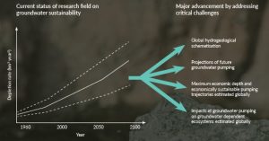
Until now, research into groundwater depletion and overuse has been limited to quantifying current and future trends in extraction or depletion rates (Bierkens and Wada, 2019). However, depletion rates per se are insufficient to estimate the critical time horizons at which groundwater reserves will become exhausted. Further, they cannot inform on the negative impacts of groundwater use. This will require insight into the volume of groundwater that can be physically and economically extracted and on the relationship between extracted volumes and detrimental impacts, such as on groundwater-dependent ecosystems. GEOWAT will help provide the missing information needed to inform pathways to sustainable groundwater use.
GEOWAT
The GEOWAT team is set to build the first high-resolution global groundwater model, supported by a 3D mapping of the world’s aquifers. We will use these unique modelling tools, in combination with dedicated case studies, to assess, for the first time, the global volume of physically and economically extractable fresh groundwater and determine the time to physical and economic depletion under future pumping.
We will also provide the first global assessment of the effects of groundwater pumping on groundwater-dependent ecosystems and explore pathways to sustainable groundwater use.
GEOWAT will provide critically-needed new knowledge to address one of the most pressing challenges that humanity will face: how to sustainably manage the freshwater resources needed to survive on this planet?
Finding this answer is particularly important for:
- regional food security, as an increasing volume of food is produced with irrigation from non-renewable groundwater (Wada, van Beek and Bierkins, 2012; Wada and Bierkins, 2014)
- the development of megacities that increasingly rely on non-renewable groundwater as a clean source of drinking water (McDonald et al., 2014; Foster, 2001; Flörke, Schneider and McDonald, 2018)
- c. global food trade as agricultural commodities produced by non-renewable groundwater are traded globally nowadays (Dalin et al., 2017)
- ecosystems that critically depend on the presence of shallow groundwater and groundwater discharge— these vulnerable areas are globally ubiquitous (Fan and Miguez-Macho, 2013; Doody et al., 2017) and are hotspots for biodiversity and ecosystem services (Constanza, 1997; De Groot et al., 2012).
Providing a global overview of regional groundwater overuse and available groundwater stocks within the context of economic and ecological sustainability is of immense global importance.
Objectives
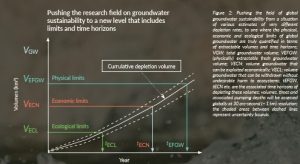
With the GEOWAT project, I will address these open research challenges with the aim to spatially determine how much groundwater there is and how long will it last (Figure 2). GEOWAT will achieve this by globally assessing the limits of groundwater use in three key objectives (KO):
- Determine the physical limits of groundwater use by estimating the volume of total and fresh groundwater, estimating how much of that volume is physically extractable, and projecting the time to physical depletion of groundwater reserves under future climate and socioeconomic scenarios.
- Determine the economic limits of groundwater use by estimating the maximum depth at which groundwater withdrawal is still profitable under current land use and future scenarios and by finding withdrawal trajectories that are economically sustainable over time.
- Determine the ecological limits of groundwater use by estimating how groundwater withdrawal affects groundwater-dependent ecosystems globally and valuating the resulting ecosystem deterioration economically.
Methods
Open global hydrogeological datasets are just now becoming available (Bierkens and Wada, 2019) . We will combine these datasets with powerful new machine-learning applications in Earth and environmental sciences (Bergen et al., 2019; Karpatne et al., 2017). Together, these will provide the essential ingredients for creating a novel global hydrogeological schematisation (HYGS) (KO 1). The HYGS will inform the specification for a physically-based global surface water-groundwater model (GLAM) that includes human water use (De Graaf et al., 2017; Sutanudjaja et al., 2018) and is the kernel instrument to estimate spatially explicit physical, economic and ecological limits of future groundwater use (KOs 1-3).
To support our global modelling efforts, we have collected a unique global dataset of hydrogeological observations (bore logs, groundwater wells with heads, salinity data, geological profiles and existing regional groundwater models). We will evaluate global results in four representative regional case studies with access to detailed models and data through my research network.
Work packages
GEOWAT is organised into six inter-related work packages (WPs).
High-resolution global hydrological and water resources modelling
WP1 will develop the backbone of the research approach; the first high-resolution 30 arc-second (~1 km) physically-based, global-scale surface water – groundwater model (GLAM). The GLAM will be integrated with the hydrogeological schematisation developed in parallel with WP2.
Global hydrogeological schematisation
WP2 will construct the first global hydrogeological schematisation (HYGS) encompassing the world’s aquifers. Results of WP1 and WP2 will be evaluated against groundwater models in the HGdb— a unique database assembled by my team (HGdb) that consists of 26 112 bore logs, 39 743 hydraulic head data, 20 692 salinity data and 20 regional groundwater model schematisations—and regional case studies (WP3).
Regional grounding (case studies)
In-depth case studies will be used to:
(a) validate the global model building in WPs 1 and 2 and to ground-truth the global-scale analyses of WPs 4-6; (b) reveal the importance of regional physiographic, socioeconomic and socio-cultural contexts in understanding past and projecting future groundwater use; and (c) elucidate context-specific and common pathways to sustainable groundwater use. Our four case studies come from known hotspots of groundwater use (Edwards and Guilfoos, 2020): Indo-Gangetic plain (McDonald et al., 2016), Ogallala aquifer (McGuire, 2009) (Kansas Geological Survey, n.d.), La Mancha aquifer (Esteban and Albiac, 2012), and the Nile Delta (van Engelen et al., 2019). Each varies greatly in groundwater governance (Edwards and Guilfoos, 2020) and physiography and are well-studied in terms of data, historical reconstructions and models (van Engelen et al., 2019; van der Vat et al., 2019; Hrozencik et al., 2017; Sanz et al., 2011; Mabrouk et al., 2019).
Physical limits
WP4 will determine the physical limits of groundwater withdrawal (KO 1) by providing the first global estimates of fresh groundwater availability (attainable volumes and supply) subject to past and future human water use. The technological strategies identified in WP3 will be used to increase the volume of extractable fresh groundwater and promote water table recovery.
Economic limits
We will, for the first time, assess the global economic limits of groundwater use (KO 2). WP5 will start with the assessment of the maximum economic limit (depth) of groundwater pumping under current water use and under future climate and socioeconomic scenarios. Analyses will provide global maps of the depth and time to economic depletion, the economically extractable volume and its economic value. Overall, results from WP5 will elucidate trade-offs between economic sustainability (e.g. income), ecological sustainability and food security.
Ecological limits
WP6 will determine the impacts of groundwater withdrawal on groundwater-dependent ecosystems (Foster et al., 2016; Eamus et al., 2015) (GDEs) and, for the first time, globally map the ecological limits of groundwater use (KO 3). Additionally, we will attempt to economically valuate the adverse effects on GDEs.
Determining global limits of groundwater use
Results from WP3-6 will be used to: identify, for regions with significant groundwater use, the order in which the three limits (physical, economic or ecological) have been or will be reached under the combined climate and socioeconomic scenarios over the period 1850-2100, as well the associated global maps (mean values and uncertainty measures) of groundwater depths, salinities, groundwater volumes and their economic value.
Two endmember cases will be compared: one where groundwater withdrawal is limited to no further exceeding additional ecological limits and one where it is only contained by physical or economic limits till 2100. We will produce and compare global maps (including uncertainty) of the economic value of groundwater withdrawal until 2100, with and without including externalities of ecosystem decline.
Finally, we will summarise and synthesise the results from the assessment of technological measures (WP4), user-driven strategies and policy-driven strategies (WP5) with insights from human-groundwater modelling in the case studies (WP3) to evaluate pathways to globally sustainable groundwater use.
Dissemination
All software and models developed during GEOWAT will be open source and made available online (through GitHub). Input and output datasets (model outputs, hydrogeological schematisations) will be freely downloadable through repositories.
For further information and to follow the progress of the GEOWAT project, visit: www.globalhydrology.nl
Project Name
GEOWAT – A Global Assessment of the Limits of Groundwater Use
PROJECT SUMMARY
Inspired by decades of excessive groundwater pumping and aquifer depletion, GEOWAT will answer the question: How much groundwater is there and how long will it last? GEOWAT will use unique global modelling tools and case studies to assess the global volume of physically and economically extractable fresh groundwater, and determine the time to physical and economic depletion under future pumping.
PROJECT PARTNERS
GEOWAT will also provide the first global assessment of the effects of groundwater pumping on groundwater-dependent ecosystems and explore pathways to sustainable groundwater use. As such, GEOWAT will provide critically-needed new knowledge to address one of most pressing challenges that mankind will face: how to sustainably manage the freshwater resources needed to survive on this planet?
PROJECT LEAD PROFILE
Marc Bierkens (1965) holds the chair in Earth Surface Hydrology at the Department of Physical Geography at Utrecht University. His current research focuses on global scale hydrology and water resources modelling subject to climate- and socioeconomic change. He was supervisor on 28 completed PhD theses. Marc Bierkens is fellow of the American Geophysical Union and a highly cited researcher.
PROJECT CONTACTS
Prof. Dr Marc F.P. Bierkens
Professor of Hydrology at Utrecht University
Vice Dean of Research Faculty of Geosciences
Vening Meinesz Building A – Room 4.68, Princetonlaan 8a, 3584 CB UTRECHT,
The Netherlands
+31 30 253 2777/2749
FUNDING
This project has received funding from the European Research Council (ERC) under the European Union’s Horizon 2020 research and innovation programme under grant agreement No: 101019185.


