Martin Brandt
Quantification of dryland trees and their carbon stocks has high uncertainty because no operational monitoring system
for non-forest trees exists.
This information is pivotal for ecological protection, carbon accounting, and guiding climate mitigation and restoration efforts. This project works towards continental-scale assessments of each tree, with a particular focus on trees outside forests. We use extensive field data collections, machine learning, and very high-resolution satellite and aerial imagery to estimate tree cover and carbon stocks at the level of individual trees. Our focus is on drylands, but we do not limit our studies to drylands.
Satellite-based monitoring of trees
Trees sustain livelihoods and mitigate climate change, but a predominance of trees outside forests and limited resources make it difficult for many developing countries to conduct frequent nationwide inventories. Satellite-based monitoring of trees enables low cost and large-scale assessments that can be rapidly repeated at a high temporal frequency. Yet these assessments are typically limited to the variable ‘forest cover’. This variable has a long tradition in forest monitoring but largely ignores isolated trees and has little use from a management perspective, and the misinterpretation of the results can cause far-reaching consequences. More specifically, these inaccuracies aggravate the existing uncertainties in estimates of both national carbon stocks and emission reference levels. They may confound the relative contributions of emissions attributed to forest degradation or deforestation. In turn, these inaccuracies in tree mapping hinder natural resource management and climate change decision-making and policy formulation.
A project at two levels
A highly precise characterisation of individual trees and shrubs from sub-metre satellite and aerial imagery
Here we localise every tree, measure the crown diameter and use allometric equations from field data to estimate the carbon stock from the diameter. The sub-metre resolution allows for the detection of trees with a crown size down to about 1m². Trees in dense forests can be separated as individuals. Some major tree species can also be identified at this level, and height can be estimated for each tree. Due to the high data and processing requirements, this work is not done at the continental level.
A precise mapping of tree cover at individual tree level using high-resolution images from PlanetScope and RapidEye nano-satellites
If trees grow in isolation, the crown size can be measured and the carbon stock estimated. The high resolution allows for the identification of single trees down to a crown size of about 15m². Forests with dense tree cover are mapped as solid forest areas. We estimate height for single trees and groups of trees. The low data amount allows for continental-scale assessments.
Major accomplishments in 2022
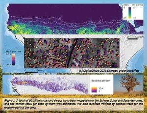
- Single tree carbon stocks for isolated trees have been estimated over the Sahara, Sahel and Sudanian zones, an area of 10 million km² with 10 billion trees (Figure 1).
- Millions of baobab trees have been located over the Sahel belt (Figure 1). Here we made use of the characteristic shape of the tree to identify individuals in the satellite images.
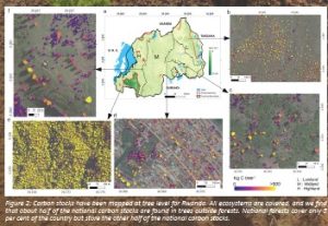
- Single tree carbon stocks have been mapped for all ecosystems in Rwanda, including savanna, farmlands, shrublands and rainforest (Figure 2).
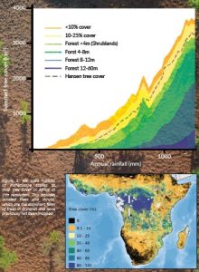
- PlanetScope images have been mosaiced at continental scale for 2019 and have been used to map tree cover at the level of individual trees for the African continent (Figure 3). First results for continental Africa show that overall the PlanetScope tree cover closely matches the previously published global map for forests and even areas with a tree cover of 10–25 per cent, especially in higher rainfall areas. However, the previously published global map completely misses trees outside forests <10 per cent, which are the dominant form of tree cover in low rainfall areas.
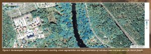
- Based on deep learning, a framework that can localise, count, segment the crown size, and estimate tree height from high-resolution images has been established (Figure 4). The framework has been tested in different settings and even works in Danish forests.
The database and framework may assist researchers, stakeholders and policymakers in monitoring tree resources in an unprecedented way, ultimately promoting more intelligent and digitalised environmental management. Moreover, the mapping of all trees facilitates any landscape stratification and is urgently needed for effective planning and monitoring of landscape restoration activities as well as for optimisation of carbon sequestration, biodiversity and economic benefits of trees.
Our work lays the foundation for a global database, where every tree has its digital twin and is spatially traceable and manageable.
Project name
Trees outside forests in global drylands
Project summary
This project aims towards a wall-to-wall identification of trees in global drylands and a study of their ecological services and socio-environmental determinants. The project will apply a new generation of satellite imagery at sub-metre resolution and extensive field data in conjunction with fully convolutional neural networks, a deep learning technique being able to identify objects within imagery at unprecedented accuracy. In doing so, we will lay the groundwork for new insights into the contribution of human agency and climate change to the distribution of dryland trees and their role in mitigating degradation, climate change and poverty.
Project lead profile
Martin Brandt received his PhD in 2014 and has been working at the University of Copenhagen since 2015. His research interest is remote sensing of the environment with a special focus on African drylands and southern China.
Project contacts
Martin Brandt:
funding
This project has received funding from the European Union’s Horizon 2020 research and innovation programme under grant agreement No. 947757.


