“Over thousands of years, a mossy landscape lived and died … but it did not decay. Trapped in ground so wet that it could not decompose, the dead ‘mosses’ instead piled up, each layer pressing those beneath into a thick, muddy mass called peat.”
Sabrina Imbler V, The New York Times.
For centuries, people have wandered onto those soggy stretches of moss seen as godforsaken wastelands and asked the same question:
What is a peatland good for?
But scientists eventually learned that peatlands hold a secret: sealed underground—and out of the atmosphere—they are the world’s largest terrestrial carbon store even though they only make up 3 per cent of the world’s land. Peatlands hold more than twice the carbon stored in all the world’s forests.
These iconic landscapes also support species and habitats that depend on these extreme, waterlogged conditions and are of international importance for biodiversity conservation. However, both their unique wildlife interest and vast global carbon store are under threat from drainage, with annual greenhouse gas emissions from drained peatland soils now estimated to be twice that from aviation. It is vital to act now to prevent further degradation and encourage more recovery of our remaining peatlands for nature, people and the planet.
At the forefront of efforts to restore peatlands in Europe are projects funded by the EU LIFE programme, such as the six-year, €7.1 million Marches Mosses BogLIFE project (LIFE15/NAT/UK/0007860) located in the UK. The project, which ended in December 2022, is a partnership between Natural England (NE), Natural Resources Wales (NRW) and Shropshire Wildlife Trust (SWT) and is also supported by the National Heritage Lottery Fund. It provides a useful case study illustrating both the progress that can be achieved given adequate resources and also the challenges and complexities involved in reversing the fortunes of a severely exploited peatland.
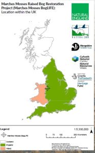
The ‘Marches Mosses’ cover Fenn’s, Whixall, Bettisfield, Wem and Cadney Mosses Special Area of Conservation (SAC) and straddle the English/Welsh border near Whitchurch in a rural part of Shropshire and Wrexham. Situated 59 km south of Liverpool, livestock and dairy farming dominate the surrounding land use.
Together, the Mosses form a 1000-hectare rainwater-fed lowland raised bog complex—a climax peatland community. The bog developed here because of the amazing powers of Sphagnum ‘bog moss’, the keystone component of peatland ecosystems. Sphagnum moss has a remarkable ability to create cold, waterlogged, nutrient-poor acidic conditions and so facilitate the slow and steady accumulation of enormous amounts of carbon in peat deposits. Over 10 000 years, this resulted in the accumulation of a saturated peat dome 10 m higher than the current flat, drained landscape. The bog swallowed up the wildwood and spread over the plain of glacial out-wash sand to the limits of its enclosing moraines.
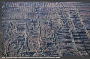
However, for the last 700 years, this wilderness has suffered an accelerating rate of degradation caused by drainage from peat cutting. Around the margins, damage has resulted from agriculture, transport systems and, more recently, forestry and even a polluting car scrapyard. The raised domes of the bog were lost, and canalisation of the ‘lagg’ streams within the peat body resulted in the unnatural ingress of enriched water.
When Dr Joan Daniels MBE, who planned the BogLIFE actions, first walked the site in the late 1980s, she despaired. The centre of the Mosses had a peat-cutting drain every 10 m, commercially cut peat was stacked as far as the eye could see, and mire plants and animals had been eradicated from most of the site. It looked like a black desert—a desert in desperate need of being saved.
Their fortunes changed in 1991 when the central area was bought by the Nature Conservancy, a government-funded body, and it was declared a National Nature Reserve (NNR). Since then, Natural England and Natural Resources Wales have been doggedly acquiring more of the bog, clearing smothering trees and bushes, damming ditches and installing storm-water control structures. Shropshire Wildlife Trust mirrored this on the smaller Wem Moss NNR at the south of the peat body. Today three-quarters of the site is managed as NNR, with the remaining parts in private ownership.
Despite centuries of peat cutting, the bog retains a substantial thickness of residual peat (on average, three metres, but in areas exceeding eight metres). The peat body remains hydrologically connected, providing conditions suitable for attempting the restoration of active peat-forming processes.
Leaping forward to 2016, the grant awarded to the BogLIFE project, from EU LIFE and the National Heritage Lottery Fund, paved the way for a huge step-change in the ambition and rate of habitat restoration. With extra resources, the project’s objective was to achieve a more sustainable, resilient, and better-functioning lowland raised bog, including ‘lagg’ restoration across 660 ha of the Natura 2000 site. Connecting people with the Mosses was another key aim of the project.
Realising the quest for ‘bogginess’ using peat bunding
Rewetting as big an area of the nature reserve as possible was the primary aim of conservation actions. The goal is to try and achieve stable ‘Goldilocks’ conditions—an average water table within 10 cm of the surface for more than 70 per cent of the year, which ideally does not drop below 40 cm of the surface.
Why? A functioning bog requires a high water table. As well as favouring the growth and spread of Sphagnum, it slows the decomposition processes and allows dead plant material to remain relatively intact in its carbon form. It was far from a straightforward task achieving stable boggy conditions, given the uneven surface topography disrupted by past peat cutting and other land uses combined with the relatively low mean rainfall the site receives a year (700 mm).
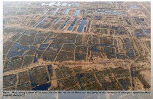
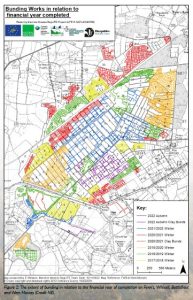
To try and produce the desired conditions of wetness, the novel technique of ‘peat bunds’ (low peat walls) was used to create watertight cells in a ring around the periphery of the project site. Elsewhere in the previously dammed central areas, lines of bunds were created following the ground contours known as contour bunds. Initially developed in Cumbria, the technique has been adapted and used on a large scale at Fenn’s, Whixall and Bettisfield Mosses. The cells are typically 20×20 m or 30×30 m and are joined to form a honeycomb-like arrangement. The bunds, which are made by repacking the peat, act to hold up the rainwater that previously leaked away unseen below the surface in the degraded shrunken oxidised top layer of drier peat.
Creating a length of bund involves a low ground pressure excavator opening a linear trench to a depth and width of 1 m to disrupt the peat ‘pipes’ or other holes in the shrunken oxidised degraded top layers of peat. Next, ‘soggy putty’ peat found deeper in the permanently saturated zone is dug from a nearby ‘borrow pit’ within the cell. This is placed in the trench and moulded to form a 15 cm high core just above the surface. This ‘soggy putty’ peat core is critical as it is largely watertight and serves as a compact barrier. The core is then covered with the top layer of turf and degraded peat to protect it from drying out. The linear bunds or low banks that result are 1.5–2 m wide at the base and up to 1 m high, although, over time, they gradually subside in height. The layout of the bunded cells was carefully planned out for each section taking into account the slope, the historical peat-cutting pattern and existing drainage ditches and drains. Where needed, storm-water pipes (300 mm) were installed through the bunds with 90-degree extension collars added to allow water levels to be controlled.
It took a mammoth effort, and by the end of 2022 a total area of 633 ha had been improved by ‘cell’ and contour bunding and a further 33 ha by damming. Laid out in straight lines, the bunds would stretch an incredible 300 km! Following the technique’s effectiveness, the area rewetted by cell bunding was increased from 337 ha originally planned to 388 ha.
Water table recovery
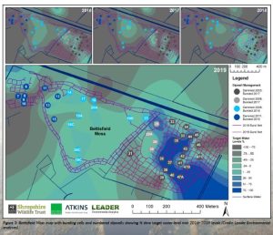
When rain falls in a bunded area, it is no longer able to escape as easily. Instead, over time, the water level rises, rewetting the top layers of the peat and stopping them from releasing carbon dioxide.
Modelling by Durham University estimates that the Mosses are an active ‘sink’ of carbon due to the progressive rewetting efforts. A small improvement in this function during the project period was predicted, with further improvement possible in the future as the bog habitat fully responds to the higher water table conditions.
Bettisfield Moss, a 50-ha part of the bog lying to the west, was the first area to be cell bunded in the autumn of 2017 and 2018. In the following year, 2019, the recorded water levels were significantly higher than previous years (9.7–18.1 cm mean increase per management group relative to 2018) (Leader, 2020). An increase in water levels was observed at 82 per cent of the monitoring points (41 dipwells). In addition, there was less variability in the water table. In 2021, target (+/- 10 cms) or above water levels were achieved 100 per cent of time at 60 per cent (21 out of the 35) of the dipwells compared to 11 per cent (4 out of 35) in 2005 when water level monitoring commenced. As a result, large areas have been recolonised by Hare’s-tail Cotton Grass Eriophorum vaginatum and Sphagnum moss.
Another promising sign of improvement has been the return of breeding snipe after an absence of 22 years. The bird is thought to have benefitted from the shallow pools created within bunded cells.
Bunding is an intensive high-impact method costing in the region of €2250–€3250 a hectare and has some repercussions for future management. The bunds that stand proud of the surface are more readily colonised by birch tree seedlings that need to be managed at intervals. In some areas, their creation has also caused abrupt changes to dry peatland habitats with potential knock-on effects on some species, such as the rare caddis fly Hagnella clathrata and the adder Vipera berus. Where possible, areas of known habitat sensitivity were taken into account when planning the bund layouts
Slowing the flow
Monitoring results show more of the rainfall is held in place on the Mosses for longer, with the cell and contour bunds and dams acting together to filter and slow the flow off-site. The flow of water leaving Fenn’s Moss measured at the main control weir was substantially lower in 2019 than before the project started in 2015. As a result, the peak flows of the watercourses downstream at times of flooding downstream will be lessened. In addition, the slow filtration of water through Mosses also helps keep the River Dee and River Roden much cleaner.
Bog edge restoration
A big part of the project involved tackling one of the most challenging problems affecting nearly all British and many European raised mires—the loss of the bog edge ‘lagg’ habitat (fen, carr and swamp communities) whose high water table helps sustain that of the mire’s centre. Forming a transition zone between the very acidic peat environment of the bog and the nutrient-rich mineral soils found in the wider countryside, this important part of the bog system often supports a rich mixture of wildlife species. Today, bog edge peatland is typically under private ownership and has been drained for a long-time and is used for marginal pasture, forestry and other uses, including as transportation routes in the eighteenth century for a canal and railway.
To restore bog edge habitats, the project partners first acquired 12 new blocks of land covering 67 ha in total around the site margins; this included 35 ha of forest and woodland and 42 ha of ex-grazing pasture. Next, five bespoke wetland restoration schemes for these areas were developed and implemented. Of necessity, several of the schemes were complex and engineered to protect neighbouring private land and dwellings from higher water levels and to secure permission from the local authority. It was particularly important to liaise with the landowners and local community to build support for and confidence in the changes proposed, given that they went against centuries of land drainage practice and orthodoxy.
Scrapheap challenge
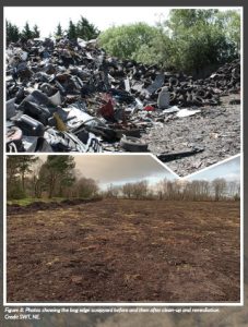
A real eyesore of the bog edge and constraint to the restoration of adjoining areas of the bog was the Furber’s car scrapyard, first established in the 1960s. Situated on 2 m of deep peat and partly in the SAC, it formed part of the original bog. Poorly managed, an estimated 600 disused vehicles were stored there in its heyday, resulting in a high pollution risk to the bog from oil and other metal contaminants.
A big opportunity for change arose when the local operator ceased trading and went out of business. To prevent it from falling into unsympathetic hands and with a vision to reclaim the 2.4 ha area for nature, Shropshire Wildlife Trust took the bold decision in 2016 to acquire it. With funding from LIFE/ NHLF and other donors, they set about remediating the land between 2017–2021.
Informed by surface and groundwater quality investigations, a remediation plan prepared by specialists was agreed upon with the regulators, and work began on the first phase involving clean-up and site clearance. An enormous venture: 700 tonnes of car-related debris, 70 000 used tyres and 27 tonnes of hazardous asbestos were removed in 40 large truck-loads for safe disposal off-site. In addition, five buildings, including a derelict brick cottage and a bungalow, were demolished and cleared.
Below ground, site investigations indicated that the peat under the concrete and hard-core surface contained moderate levels of pollutants like heavy metals, petroleum-related by-products and asbestos that could cause damage to the sensitive bog habitats if remobilised. Specialist advice was to avoid disturbing Pandora’s box to minimise the risk of pollution being released. This meant leaving the concrete pad and hard-core surface in place to avoid the disturbance of the contamination held below ground. Instead, the recommendation was to cover the permeable non-sealed hard-core areas with an impermeable membrane and then a depth of 40 cm of clean soil on top to form a natural capping. Fortunately, ample clean topsoil and turf were available from local pasture fields on peat included in the project’s pasture-to-bog trials: 11 000 m3 of soil were sourced from six fields covering 3.1 ha and used to landscape the scrapyard.
The most recent water quality tests show benign results, and with the surface debris cleared and the soil cap in place, the local authority has indicated that they are satisfied that the pollution risk is adequately mitigated. The total cost of remediation work was approx. €775 000. It’s over to mother nature now. The site has rapidly developed a green mantle of vegetation, and a barn owl is regularly seen quartering over the area, indicating that wildlife is already returning and taking hold. Over time it is expected to develop into a mosaic of wet woodland, a habitat typical of bog edges.
Pasture on peat to bog trial
A trial involving the reversion of 3.2 ha of under-drained peatland from marginal pasture fields owned by Natural England to active bog habitat was carried out on the edge of Whixall Moss. Drained pasture produces high levels of greenhouse gas emissions compared with rewetted bog, which is less than a fifth of these (Evans et al., 2017). As the drive to increase the area of healthy peatland increases, it is important to learn how areas of the bog improved for grazing pasture can be restored to increase both their biodiversity and carbon storage and sequestration value.
The method trialled here involved three sequential stages:
- the removal of enriched topsoil to a depth of 35 cm
- raising the water table to just above the height of the peat surface by the creation of cell peat bunds and the breaking up of the land under-drainage pipes
- planting or spreading mixes of Sphagnummoss species across the area.
Using the latest laboratory and nursery-based replication techniques, Micropropagation Services Ltd grew and supplied 116 000 plug plants and 1500 litres of Sphagnum gel (1 ml can produce more than 100 plants) generated from small samples of bog mosses collected from other areas of Whixall Moss. Two types of Sphagnum mosses were made up, a Bog mix and Fen mix. These were spread and planted in two forms, BeadaMoss™ and BeadaHumock™. To prevent the delicate plants from drying out, a mulch of dried straw was applied shortly afterwards, and in April 2021, 8 000 plugs of hare’s tail cotton grass (Eriophorum vaginatum ) were also planted to serve as a nurse crop.
Achieving favourable and consistent water levels conducive to Sphagnum growth has been problematic, with significant parts of the trial area fluctuating between being either too wet or too dry. When several areas of turf-stripped and bunded pasture became too wet for Sphagnum planting, 48 000 plugs were instead redeployed to trial their use in areas of cleared forest being reverted to bog. In total, in the ex-woodland area, 35 bunded cells (approx. 20×20m) each received 1200-1600 plugs.
While the trial remains at an early stage, it is evident that without a consistent water supply in the summer and the means to actively manage excess water levels in the winter, the establishment of a high coverage of Sphagnum will be slow to develop if it succeeds at all.
Forest to bog restoration
From the 1960s, significant areas on the margins of the peatland habitat were drained and forestry ploughed and developed as commercial conifer plantations. On drier drained areas, birch woodland developed, in part when traditional burning management tailed off.
As part of the project, 50 ha of recently acquired conifer plantations in Northeast Fenn’s Moss were commercially harvested by NRW. Seven thousand tonnes of timber and chipped material was recovered and utilised by a local timber mill. To aid the later planned peatland restoration phase, branches, tree offcuts and other debris were cleared, leaving a very clean site compared with standard forest harvesting practice. Minimal ground disturbance was allowed; stumps were cut low, and ‘brash tracks’ were limited to arterial routes for extraction, which were removed as far as possible upon completion.
Before cell bunding of the area was possible to raise the water table, tree stumps and their root plates along the planned bund lines had to be lifted by an excavator, moved to the side and then pressed into the peat. As a result of this extra operation, the cost of bunding ex-forestry areas worked out roughly double that for open peatland. The bunds in ex-forest areas lack a turf cover and are thus prone to birch tree regeneration along the bund lines. By the end of the project, only 6 per cent of the project area (47 ha out of 793 ha) remained covered by woodland—down from 26 per cent in 1991.
Diversion of nutrient-rich water: reverse engineering the peatscape
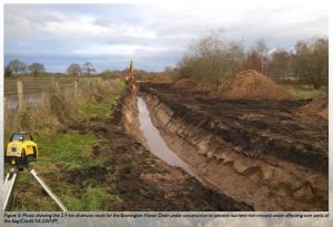
Bog vegetation thrives in low-nutrient rainfall-fed conditions, but this rapidly changes under elevated nutrient levels. As a legacy of the 1823 Enclosure Act, five artificial canalised drains connect the Mosses to the surrounding landscape. As well as helping to drain water off the Mosses as rapidly as possible, they create another problem by enabling unwanted nutrient-rich water from the surrounding farmland and septic tank discharges from houses to flow onto parts of the Mosses, changing their ecology. As part of a sizeable engineering undertaking, a 2.9 km length of the Bronington Manor Drain on the northside of the site was re-routed to the site’s mineral edge, enabling the diversion of nutrient-rich water away from areas of the bog under restoration by peat bunding. Early results indicate the work has been effective, and the water quality of these peatland areas is improving.
Aerial nitrogen pollution and SNAP
At three times the recommended level for bogs, the high atmospheric nitrogen deposition (21.7 Kg N/ha/yr) the site receives is a major ecological pressure, and it is seriously affecting species richness and composition of the SAC bog habitats. More worrying is a looming ‘cocktail effect’ predicted to kick in and worsen the problem. Research indicates that nitrogen-enriched peatlands, like Fenn’s and Whixall Mosses, may be poised to change rapidly from carbon sinks to sources due to a potential increase in droughts caused by climate change warming. High nitrogen deposition triggers far more vigorous growth of undesirable vascular plants, like Purple Moor Grass Molinia caerulea and birch, to the detriment of the important peat-building Sphagnum moss vegetation community.
To start tackling this long-term problem, the project developed a shared nitrogen action plan (SNAP) for the site. Serving as a pilot for this approach in England, the aim is to integrate national and local approaches for achieving air pollution improvements and work with stakeholders locally to produce supported actions.
The first stage involved evidence gathering and a technical characterisation of the site’s aerial pollution problem using the best available information. To improve the understanding of the spatial pattern of ammonia deposition, the number of monitoring locations on-site was increased from one to four between 2018 and 2022. The analysis identified that agricultural activities within 5 km of the site boundary accounted for over half of the emissions, so this zone was highlighted as an early priority. At the same time, an on-site trial was run across nine hectares to assess four management methods to control the over-abundance of Molinia caerulea arising in large part from high nitrogen deposition. However, after three years of observations, none of these was found to be either practical or effective to apply at scale.
An initial workshop with key stakeholders was held in July 2018 to introduce the SNAP and share knowledge. In 2021 a SNAP coordinator was appointed and, together with the local Catchment Sensitive Farming (CSF) officer, engagement with local farmers to raise awareness of the issue and to promote available grants and incentives started. The National Farmers Union have remained a key partner throughout the SNAP pilot. These are early days, but the feedback from stakeholders is positive, and policymakers are becoming aware of the value of the site-focused coordination approach. NE has expanded the number of pilot SNAPs to four, and SNAPs were cited in the UK Government’s Clean Air Strategy 2019 as an example of innovation and leadership.
Connecting the Mosses with people: achievements
Engaging people was a key part of the project. The aim is to change the way people perceive the Mosses and to make the place more accessible, inclusive, better interpreted, and the place respected for its intrinsic value and the services it provides.
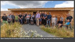
The new ways for people to access and appreciate the Mosses have proved popular. There has been a big jump in visitor numbers since the start of the project. A big hit has been the new 5 m high The Mammoth Tower, which allows visitors to gain a birds-eye view of the bog while finding out about peatlands and carbon storage. The creatively designed new bird hide overlooking the Sinker’s Fields is equally valued by families and bird watchers alike. Added to this is much improved and innovative interpretation signage, walking trails and new online information and leaflets improving the visitor experience.
A total of 291 people volunteered and helped with conservation management and monitoring. It amounted to 2362 days of their time with an estimated value to the project of €275 327.
Over 150 public events were arranged (e.g. guided walks, talks, or bog-related activities) and attended by over 3500 people. The project also ran 25 dissemination events, either in person or online, covering technical aspects of the restoration.
Over 500 primary school children and 600 Year 12 students have been introduced to and educated about the Mosses, and just under 100 teachers have been engaged, giving them the tools and confidence to take students on-site.
A particular focus was activities that reach out to sections of the community that are less easy to connect with. This included parent and toddler groups, youth clubs, families, the elderly, people with access issues, horse riders, dog walkers and local youth clubs.
A range of resources has been created for continued community engagement. One example is Bouncy Bog which has a replica bog and several wildlife puppets, including a dragonfly and raft spider. Another is Bog-in-a-box, which takes the Mosses to people with a small bog section in a bucket, accompanied by images, natural history objects, snake skins and a replica egg.
Mosses were explored through art by local artists. They created an Art Trail of sounds and sculptures on the Mosses in 2021 and, working with young people, created three art banners celebrating the landscape of the Mosses. This led to a collaboration with the Macquarie Marshes in Australia to explore the use of art to transform how we think about wetlands.
Media engagement resulted in the creation of 50 media releases with an estimated reach of five million people. The project gained television coverage, specifically on the popular BBC programmes Countryfile and Springwatch.
The project also ran a successful trainee employment programme, with all seven trainees having gone on to jobs in the nature conservation sector.
And finally
What will the next 30 years bring? The last six years have just been a blink in the eye of a 10 000-year-old bog. The project’s legacy must be sustained and built upon. The threat of climate change is urgent and growing. Reviving the Mosses and protecting the one million tonnes of carbon stored in its peat will prevent that CO2 escaping into the atmosphere. Continuing the work started 30 years ago will ensure a home for the biodiversity on this precious site, store even more carbon and maintain a special place for people to reconnect with nature.
References
Evans, C., Artz, R., Moxley, J., Smyth, M-A., Taylor, E., Archer, N., Burden, A., Williamson, J., Donnelly, D., Thomson, A., Buys, G., Malcolm, H., Wilson, D., Renou-Wilson, F. and Potts, J. (2017) Implementation of an emission inventory for UK peatlands. Natural Environment Research Council Centre for Ecology and Hydrology, pp. 88.
Imbler, S. (2022) Meet Peat, The Unsung Hero of Carbon Capture. Available at: https://www.nytimes.com/interactive/2022/02/21/headway/peat-carbon-climate-change.html (Accessed: 16 February 2023).
Leader, S. (2020) Marches Mosses BogLIFE Project: Hydrological Analysis Fenn’s, Whixall, Bettisfield and Wem Mosses NNR: Hydrological analysis of water levels and water flows and their response to management LIFE15 NAT/UK/000786. Unpublished report.
Project name
Marches Mosses BogLIFE project
Project summary
The project involves the recovery of the UK’s third largest lowland raised bog at Fenn’s Whixall, Bettisfield & Wem Mosses SAC on the England/Wales border. Using innovative rewetting techniques, the aim is to restore 665 ha of peatland habitat affected by peat-cutting and its ‘edge’ lagg habitat to transform it into a healthy functioning ecosystem for nature, people and the planet.
Project partners
A partnership of three organisations, the associated beneficiaries are Natural Resources Wales, the public body looking after the environment for people and nature in Wales, and Shropshire Wildlife Trust, a conservation charity committed to creating a Shropshire rich in wildlife for everyone. Natural England is the coordinating beneficiary.
Project lead profile
Natural England is the government’s adviser for the natural environment, helping to protect England’s nature and landscapes for people to enjoy.
Project contacts
Robert Duff
Natural England
Marches Mosses BogLIFE project,
Fenn’s, Whixall & Bettisfield Mosses National Nature Reserve,
Manor House, Moss Lane, Whixall, Whitchurch, Shropshire, UK SY13 2PD
+44 7970 286 444
robert.duff@naturalengland.org.uk
www.themeresandmosses.co.uk/marches-mosses-boglife
Funding
The Marches Mosses BogLife project has received funding from the LIFE programme of the European Union under grant agreement No. LIFE15 NAT/UK/000786. The National Heritage Lottery Fund also supports the project.


